Public domain maps
Imagine that you want to digitally scan some existing maps, make a few changes to them, publish them yourself, and sell them as a collection. Can you do this? Sure, no problem … if the originals are public domain maps.
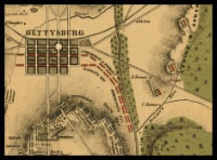
Maybe you want to compile a collection of Civil War maps. Like the one you see here, for example, which is a detail of a map from the American Memory collection at the Library of Congress. It’s from Map Collections: Civil War Maps, 1861–1865.
How do you know if a map is in the public domain?
Here are the main reasons a map could be in the US public domain:
- The map was created by the US government.
The federal government is the greatest source of public domain maps in the United States. There’s an entire alphabet soup of federal agencies creating maps all the time — and works that US government employees create (as part of their jobs) are not protected by copyright. For more information, see this page of the tutorial.
- The map’s copyright has expired.
Copyright doesn't last forever (at least not yet), even though the US Congress has extended the copyright term 11 times in the last 43 years (since 1962) ... as opposed to just twice, in 1831 and 1909, during the preceding 172. For more information, see this page of the tutorial.
Copyright terms expire. All maps published in the United States before 1923 are in the public domain because their copyrights have expired. Say hallelujah, everybody.
- The map was published before 1989 without a copyright notice.
Copyright notices used to be mandatory. If a work was published without a proper notice, it went into the public domain unless the copyright owner corrected the problem within a specific period of time.
A valid copyright notice on a map had to consist of at least these 2 elements:
- the copyright symbol ©, the word "Copyright," or the abbreviation "Copr." and
- the name of the copyright owner.
Like so: © Lenny Longitude
Maps published from January 1, 1978 through March 1, 1989 also had to include the publication year. (Maps published before 1978 didn't need to include the date). For more info, see this page of the tutorial.
- The map wasn’t eligible for copyright in the first place.
I'm not talking about US government works here. We know that those don't get copyright protection. But there are “originality” and “minimal creativity” requirements for copyright in the US.
If the components of the map are “entirely obvious” the map will not be copyrightable. For example, an outline map of the state of Texas, or one of the US showing the state boundaries is not copyrightable. (Not creative.) Ditto maps that use standard cartographic conventions, like a survey map. (Not original.)
This is could be a tough call in certain cases (I mean, come on ... “entirely obvious”?) but that's the what the courts have said. Just keep in mind ... what you think is entirely obvious, the mapmaker might contest as creative.
To learn more about how to tell if a work is in the public domain for one of these reasons, and more, check out the tutorial on copyright and the public domain.
Did you know that parts of a map can be in the public domain?
Not every part of a map can be protected by copyright. If some parts of a map are in the public domain, you may use them freely.
What parts can you use without permission? These:
- Place names. Those aren't copyrightable.
- Colors. For example, the colors representing area features on a topographic map, such as vegetation (green), water (blue), and densely built-up areas (gray or red). Colors aren't copyrightable, either.
- Symbols and map keys. Can't be protected by copyright, even if the mapmaker invented truly original ones.
- Geographic or topographic features. Those are facts, and facts aren't copyrightable.
- Stuff copied from other maps (say, from a public domain USGS map). Whatever new information the mapmaker added will be protected by copyright (the selection, arrangement of the info), but the stuff that was copied (the elements of a USGS map used as a starting point, for example) will stay in the public domain.
For more information on stuff that’s not copyrightable in the US (no matter what some greedy souls might tell you), see this page of the tutorial.
Okay, enough talk about how maps can be in the public domain ... check out this list of places where you can find public domain maps.
© www.publicdomainsherpa.com | * legal information is not legal advice *

Except where otherwise noted, the content of this web site is licensed under a Creative Commons License.